

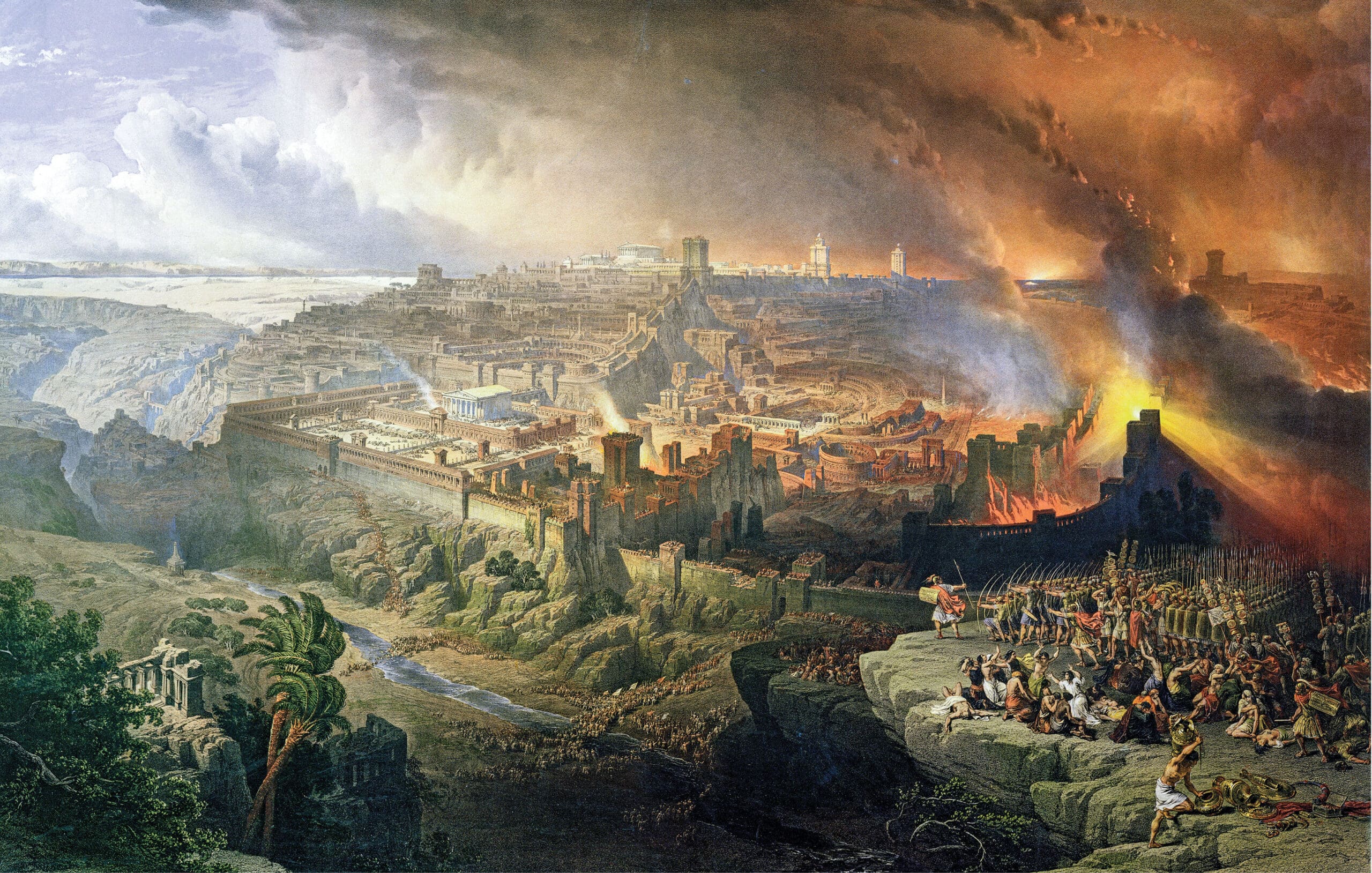
David Roberts, The Siege and Destruction of Jerusalem, 1850. Public Domain, via Wikimedia Commons.
The Roman army’s conquest and destruction of Jerusalem in AD 70 is well documented, both in contemporary written sources like Josephus and in the archaeological record. At the southwestern corner of the ancient Temple Mount, for example, massive ashlar stones toppled from the upper courses of the sacred precinct’s walls are strewn like playthings, testifying to the immense force brought to bear against the city. To commemorate the conquest, the emperor Vespasian issued celebratory coins that read Iudaea capta, “Judea captured”; and in Rome, the triumphal arch of Titus, named for the general who led the Roman army in Judea and later became emperor himself, is adorned with imagery that includes the looting of the Jerusalem Temple.
Yet, despite all this evidence, little is known about the layout and organization of the protective walls, garrison camps, and other defenses that made up the Roman army’s siegeworks during the conquest of the city. In his article entitled “Under Siege: How Rome Conquered Jerusalem,” published in the Spring 2026 issue of Biblical Archaeology Review, archaeologist Győző Vörös pieces together the available evidence to develop a clearer picture of the disposition of the Roman forces.
According to Vörös, the absence of physical remains from the Roman army’s siegeworks is likely due to the rapid dismantling of these structures once the city fell. In order to resist potential counterassaults by Judean rebels still entrenched at other locations, the Romans quickly turned to the refortification of the city itself.
Some details, however, are preserved in Josephus’s Jewish War, where the siege is described at length. For example, Josephus notes that the entire circuit of Jerusalem’s walls was 33 furlongs (3.8 miles) in length (War 5.159); that the Roman siege walls built around the city totaled 39 furlongs (4.5 miles) in length (5.508); and that those walls were erected at a distance of two furlongs (about 1,200 feet) from the city’s walls (5.270). This suggests that Josephus was either present himself at the battle or had access to Roman military records of the siege.
Jerusalem was protected by a series of fortifications known as the First, Second, and Third Walls. The First Wall, built some two centuries earlier during the Hasmonean period, encompassed the city’s southwestern hill, roughly corresponding to the city’s Iron Age wall. The Second Wall, possibly built by Herod the Great (37–4 BC), encompassed an area to the north, with parts of its route following the northern side of the current Old City wall. The Third Wall greatly increased this northward expansion; in fact, it was completed shortly before the siege began. Excavations in 2015 exposed a portion of the Third Wall on the city’s western side that must have been under heavy fire by Roman artillery during the siege, judging from the multitude of ballista stones and other weaponry discovered just outside the wall.
Become a BAS All-Access Member Now!
Read Biblical Archaeology Review online, explore 50 years of BAR, watch videos, attend talks, and more

Remarkably, the standard reconstructions of Jerusalem’s entire fortification system measure almost exactly 33 furlongs (3.8 miles) in length—precisely the figure recorded by Josephus. This lends support to the supposition that his notes about the Roman siegeworks are likewise reliable. With this in mind, in 2024 the Hungarian Academy of Arts began investigating the likely route of the Roman fortifications encircling Jerusalem. The task was complicated by the existence of the modern city, which obscures much of the ancient topography; but the team relied on a 19th-century topographic map produced by the Dutch cartographer Charles William Meredith van de Velde. With this as their guide, they used Geographical Information System (GIS) and GPS technology to plot the course of the Roman circuit wall and the 13 garrison camps along its length, making sure to bear in mind Josephus’s indication that these structures should be two furlongs (1,200 feet) away from the city’s walls.
When the team completed their work and overlaid their findings onto Van de Velde’s map, the two fit together perfectly, with the wall following the natural contours of the local topography while also remaining at an elevation that was equal to or above that of Jerusalem’s fortifications. The team then turned to historic aerial photographs of the area as a way of helping them to visualize how these structures worked within the local landscape. This enabled them to produce a reconstruction of the Roman siegeworks.
For more on the Roman siegeworks used in the conquest of Jerusalem, read the article by Győző Vörös entitled “Under Siege: How Rome Conquered Jerusalem” in the Spring 2026 issue of Biblical Archaeology Review.
Subscribers: Read the full article, “Under Siege: How Rome Conquered Jerusalem” by Győző Vörös, in the Spring 2026 issue of Biblical Archaeology Review.
Not a BAS Library or All-Access Member yet? Join today.
Related reading in Bible History Daily
All-Access members, read more in the BAS Library
Recovering Roman Jerusalem—The Entryway Beneath Damascus Gate
Not a BAS Library or All-Access Member yet? Join today.
The post The Roman Conquest of Jerusalem appeared first on Biblical Archaeology Society.
Comments
Post a Comment